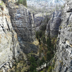
Cayuse Creek, 11km west of Syringa campground, is a great place to explore on a hot day. The canyon is filled with all kinds of waterfalls, rock slides, and pools. Visit in late summer because the canyon is dangerous otherwise due to spring runoff.
The Labarthe Tunnel dates back to the early days of the Columbia & Western Railway. When the Arrow Lakes were flooded during the construction of the Keenleyside Dam, a portion of the railway had to be rebuilt upslope. The Labarthe Tunnel was on one of the portions cut off during the rebuild.
Depending on the level of the reservoir the Labarthe Tunnel can be submerged, partially submerged or completely dry! For a kayak adventure, obviously partially submerged is the goal!
The section of abandoned KVR track between Coquihalla and Portia stations is getting more and more difficult to navigate but there are some hidden gems hidden in the mountains for KVR enthusiasts - tunnels, snowsheds, waterfalls and countless railway artifacts.
A rough route is shared by the trans-mountain pipeline service road which can be a safe alternative when the railway right of way becomes impassible.
It's always interesting to paddle a chain of lakes and one such chain exists above Lake Country BC. It is possible to paddle from Dee Lake to Island Lake to Deer Lake to Crooked Lake to Beaver (Swalwell) Lake in a day of paddling but there are so many options for rugged lakeside camping that it's worth making it a 2 day trip.
We chose to start at Dee Lake Rec site which involves carrying gear 300m from parking to lakeside. From here it is a straightforward paddle until the dam between Crooked and Beaver lakes. It is a short and manageable portage. We camped on an island in Deer lake but there are dozens of potential camping spots (see map below). While it is possible to park vehicles at both ends, we decided to stash bikes at one side and it ended up only taking 40 mins to bike around the lakes along the forestry road.
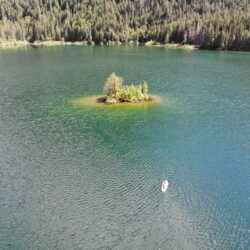
Spectrum Lake Island (yes we hiked in a paddle board)
Spectrum Lake was that location that we used to walk by on the way up into the Monashees. In recent years with young children, it has become a great little weekend destination for beginner backcountry experiences. This has been the revelation by many many others and now hot Saturday nights are filled to capacity and then some. Nevertheless it is a picturesque spot worth the effort for a couple nights of camping.
Spectrum Lake is the only backcountry lake that I can think of in the region that has a dock. At face value this doesn't seem like a significant feature but it has become sort of the campground hang out and mingling hub. Most backcountry lakes are frigid and it is difficult to get aquainted with more than the first few meters of the shore. The Spectrum dock gets you away from the trees and out into the lake to take in the majesty of the surroundings. Wow a whole paragraph about a dock.
Aside from the noted dock, there is also an outhouse and bear cache.
https://youtu.be/8bqq7xAo4Ak
In recent years, the path to the waterfall near the lake has become more well known and more accessible. Find it by walking past the bear cache and crossing the log across the river at first opportunity. Navigate the log gauntlet for a bit and be shocked at how the waterfall was bigger and better than expected!
This may have been anecdotal but in the worst year for bugs in living memory (summer 2022), Spectrum Lake had very few. Maybe it is a special spot!
The abandoned fire lookout on Mt Hamilton (Quilchena, BC) seldom sees visitors since the surrounding landowners have stopped public access up the service road. There is crown land on several sides of Mt. Hamilton which makes for the only legal access at the moment. I chose to hike in (see map below) from the west side off Pennask Lake Rd which ended up working but it is by no means an easy or straightforward route.
There are two obvious access points to Rattlesnake Mountain that should NOT be used. The first is the network of trails seen on the Alltrails app starting off Garnet Valley Road. This is private land and the landowner will ask you to leave. The second is seen on various Summerland city literature with trailhead at the end of Cristante Road. There is a locked impassible gate at the end of Cristante Road with no access.
Some have been parking along Sandborn Road where the new Hunting Hills subdivision is under construction. Many report having no issues starting here but officially it is not allowed because of ongoing construction. Use at your own risk.
It is apparently possible now to contact Wild Horse Ranch and with their permission, park below their driveway and hike through their property. This looks like the most viable option as of summer 2022.
A potential access point (not verified yet) would be to try accessing off Garnet Valley Road 1.2km north of Jones Flat Rd. Parcel 18654 is municipal land (search here) designated as park so theoretically should avoid any private land (but nearby parking is an issue).
See the google map below for more details on all access related issues.
Hiking the cliffs along the west side of the summit
https://youtu.be/Vk8fZ2r_h8g
Important Trail Information
There is no trail up Rattlesnake Mountain. Route-finding is necessary although this is not so hard as there is very little undergrowth. At times the Goat Trail (mountain bike trail) heads in a useful direction for hikers and at other times animal trails are available. There are no obvious trails close to the 'summit.'
There are viewpoints at the top of Rattlesnake Mountain over the beautiful Garnet Valley as well as in every other direction across the Okanagan. The rugged cliffs at the west side of the mountain are of particular interest.
The hike (using route highlighted on the google map) is approximately 9km round trip and takes around 3 hours.
Cliffs along the west sideView to the south - Giants Head a notable landmark
*note that while government websites suggest the Vaseux Protected Area has hiking options, it is surrounded by private property and Osoyoos Indian Band Lands making access difficult*
The Vaseux Protected Area has a number of features that would have interest for the exploring hiker. Gallagher's Bluff stands out as one of the prominent bluffs in the area (along with McIntyre Bluff). There is also the Vaseux Creek Canyon with its stunning vertical walls. The protected area is of course a great spot to view California Bighorn Sheep.
A government document states that access to the Vaseux Protected Area "Site 1 is accessed from a gravel road and site 2 from the Okanagan Falls Service Road." This does not provide enough detail and there is no indication on related maps of where these access points lie. One potential option is to hike up from Gallagher Lake.
View from Gallagher Bluff (with McIntyre Bluff in the background)
In the mid 1800s, the route through the Fraser Canyon to northern goldfields became known as the Cariboo Wagon Road. As time progressed, the route eventually modernized and a hundred years later became the TransCanada highway. Upgrades to the route left some abandoned gems for explorers with whispers of a not too distant history.
The Alexandra Bridge sits abandoned in a quiet forest along the Fraser River (when trains aren't going by). It's a wonderful, almost magical spot to explore. The bridge was in use along the original Cariboo Wagon Road before the road was rerouted over a newer bridge.
The Kettle Valley Railway entered the Fraser Canyon at the engineering marvel known as Othello Tunnels. Due to a devastating storm in Nov 2021 the tunnels were damaged and closed. This didn't stop us from biking the KVR route from Hope to take a peek at the current state (apr 2022):
https://youtu.be/4oS_cIssX6o
Damaged Othello Tunnels
Back up the Fraser Canyon, the rain started to fall hard so it was time to head into the forest to get lost searching for a strange treehouse:
When we heard that there was still some wreckage to be found south of Hope from a 1966 airplane crash, we had to see if we could find it. Attempting just after winter wasn't the greatest idea but we managed to survive the trek!
Crawling over boulders searching for wreckCrawling over boulders searching for wreck
Nearby plaque detailing 3 disasters in the area (hope slide + 2 plane crashes)
One interesting aspect of this particular aircraft is the readily available information online about the crash and the type of airplane. There are even exact pictures of the aircraft. It was a Royal Canadian Air Force owned Grumman CSR-110 Albatross #9302.
On 23 April 1966, the aircraft departed RCAF Station Comox, British Columbia and crashed on the Hope Slide near Hope, BC. Five crew members were killed but miraculously, the sixth survived.