Mount Boucherie – Get Lost Surrounded By City. It actually doesn’t surprise me anymore when I read in the news that another rescue was made after a group got lost on Mount Boucherie. Yes, we are talking about an intra-city hill that is only 2.5 square kilometres. Yes, there are hardly any trees on the hill so it should be easy to find the way back. I’m not surprised because even my own mother got lost and had to be found by the RCMP K9 unit. She had lagged behind and missed a turn only to wander around semi-frozen and disorientated in the residential area south of the mountain. I guess it is an old volcano – that sounds dangerous.
So now are we ready for Kelowna’s best intra-city hiking adventure?
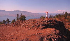
Mount Boucherie – Get Lost Surrounded By City

There are a number of access points to get up the Mountain. The most pleasant is Eain Lamont park and the loudest is just off the highway on the north side. In 2015, the ‘rush trail’ heading up the west side of the mountain was opened for hiking and cycling. No matter what route is taken to the top, the views are shocking on a clear summer day. With the lack of tree-cover, 360 views are attained across Kelowna, Okanagan Lake, and the surrounding Mountains.
It’s also very manageable with kids.
Directions To Trailhead:
Eain Lamont park is the best starting point for a Boucherie hike and is a couple turns off Boucherie road in West Kelowna. To ascend while listening to the sounds of highway 97, take the Ross Rd exit and there is parking off Hewl Rd. For the Rush Trail, take East Boundary Rd off the highway and the trail starts not far south of Daimler Drive. In all cases, follow trails heading upward and 30-40m should get you to the top without too much trouble.

Walking time: 1-3 hours
Trail Length: 2km round trip
Elevation gain: 165m
Easy to Keep on Trail: not always, there are lots of intersecting trails.