Cambodia’s highest peak is Phnom Aoral at 1813m. While only 100km from Phnom Penh it is incredibly remote and difficult to access. For those that have the patience and fortitude, this is one of Cambodia’s great adventures. The mountain itself is nothing special and not a terribly difficult hike – getting to the trailhead is the part that is hard. Let’s be frank. This hike is not easy for tourists or short-term visitors. To pull this off independently is nearly impossible unless someone in the group has a decent command of the local language and customs, a general lay of the land, and experience with travel in rural Cambodia.

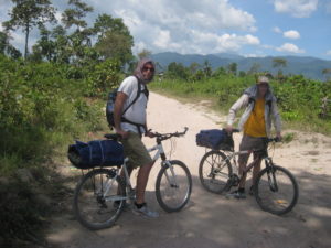
The trailhead is off the beaten path, down roads that are difficult to manoeuvre with any vehicle. Dirt biking is probably the easiest way to get to the trailhead. I prefer more simple travel and have accomplished the hike once by driving regular motorbikes from Phnom Penh and another by renting a private van to drop us off with our bicycles. The most fun was the latter.
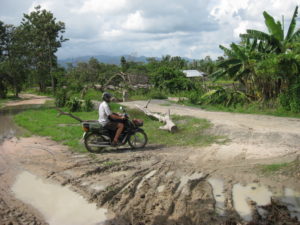
Theoretically it should be possible to access the mountain from a number of directions but I’ve only heard of successful attempts from the south. Sre Kan is the name of the village at the end of the road (Srae Kan 3). This is already 19km from the main road. It’s not too much further after that before the trails begin to incline towards the mountain. I did say ‘trails’. Yes, trails branch in all directions through jungle and bamboo forest. There is no way you can just stumble upon the correct trail.

Guide
The hike can be done without a guide – I did it on my second ascent but only by following my previous GPS trail. It is pretty easy to pick up a guide in Sre Kan. You can literally show up and someone will drop whatever they’re doing to make a month or more salary in one shot. In the grand scheme of things, the 20-30USD that it will cost is well worth being able to just show up and get things arranged pretty quickly. Often the village leader will be contacted to get a sense of what’s going on and to arrange who will guide.
Camping
This is no day-hike. Unless all the logistics work out perfectly, it’s can easily be a 3-day trip. It’s convenient to spend a night in Srae Kan and another on the mountain. Staying the night on Srae Kan means throwing up the jungle hammock on someone’s porch or perhaps finding a homestay. Camping on the mountain is a different story. Be prepared to bring everything including food, bedding, and lots of water. There are a couple places with stream access on the mountain but only at certain times of the year. It is also FREEZING on the mountain at night. With a jungle hammock, warm clothes and even a fire it is a chilly shiver-the-whole-night kind of sleep.

All that remains is the question – why the heck would you ever want to go twice! Well, the answer to that is you don’t, ever. Except after returning to Sre Kan, someone told me that if I came back again, they would lead me to the crash site of an old airplane. It took two years to get the courage to even attempt that one.
Based on original travel tale – Summiting Cambodia’s Highest
So did you see the airplane crash site? Dying to know….
absolutely!
Hi I’m planing to go there on next month.. can you send me the details.. .. and the details of crash site also..
thanks
Milinda
I was hoping you could email me a copy of the gps track to Cambodia’s highest mountain. I will be visiting in two weeks with the primary goal to summit.
Thank you
Travis
Hi Steve,
It was very helpful to read your hike blog for phnom Aoral. We plan to attempt the summit next weekend as well. Would you mind sharing the GPS locations with us? Is it really necessary to keep the fire burning the whole night? Do you have any other tipps, you didn’t mention in your blog. Do you maybe have any phone number of a local from the village? If you please, it would be cool to get the GPS location of the crashed airplane, too.
Thank you and best,
Raphael
Sent personal email. Let me know if you didn’t get it.
Hi Steve, great blog post.
Any chance you could email me the GPS location for the mountain and for the village you started in? Thanks!
Hello, thanks for your post. I plan to go there (Aoral peak and airplane crash site), can you send me your GPS tracks please? Do the guides from Sre Kan village provide all equipment and food? How much would such a trip (3 days 2 nights on the mountain) cost per person?
Hi Steve… Thanks for the post and the info. Can you please share the GPS of the plane? Cheers.
I live in California, USA. Visiting Cambodia on March 23, 2024. Would like to hike “Phnom Aural”. I. Looking to for a guide. Does anybody have a suggestion
Thanks
Wasim Khan.
Nice post! I am also planning my trip to Mt Aoral in late March 2024. I only found one GPS track on Peakbagger.com
Cheers!
Thank you so much for your post, Steve. It’s really impressive and of course helpful. I am planning my trip for next week. Can you please send me your GPS trail (maximebraguier@gmail.com)?
Thanks in advance.
ok, will do!
Hi Steve! thank you for the blog, it gives some good insight into the nature of the hike. Could you share with me the GPS data? the plane crash site sounds interesting as well… is it far off the beaten path? I wonder if there even is a beaten path or whether you just walk through unmarked jungle the whole time.
Cheers!
Hi Eyal, yes VERY VERY far off the beaten path. I am hesitant to share GPS info because it has got some groups into trouble trying to venture out on their own into complete wilderness.
Hey Steve! Is it possible to get gps track of your trail for my e-mail address? I’m planning to summit the Phnom Aural soon and want to have a look before!
Thank you so much!
Hi Natalia, sorry for the extremely late reply. I’ll send you an email.
Hello Steve, do you think that if i take a guide in the village they will bring the hammock for me? I am backpacking and i don’t have hammock or hiking gear except for hiking shoes.
Hi steve, i have no hiking gear except for shoes, do you think that if i go to sra ken i will find a guide to take me up that has tent and food?
No, I think this is a bad idea. This is not a popular activity and there are no guides per say – just people with other jobs that could possibly drop that for a day or two to show you the way. There are definitely no camping or food provisions available to make ready for you. This is something that takes some careful planning and preparation. I have memories of not sleeping on the mountain because it was so cold and wet. There are real dangers to prepare for.