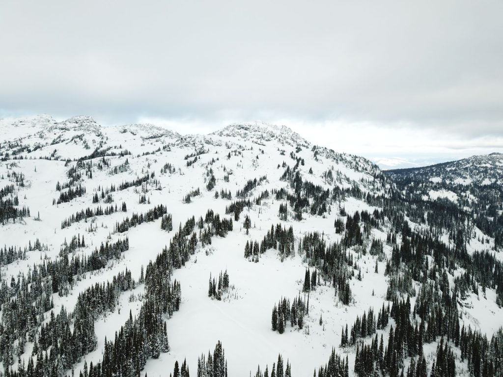
Mara fire lookout is on the summit of the highest mountain of the Hunter Range (Morton Peak). This is the range in the North Okanagan sandwiched between Enderby, Mara Lake and Sicamous to the west, and Mabel Lake to the east. To add some confusion, there is also a Mara Mountain (without a fire lookout) just to the south.
Typical landscape of the Hunter Range
Access:
There is ATV road access from both the north and south. Hikers can park on Owl Head FSR to access from the north or drive up 3 Valley Mabel / Mara Lookout FSR as far as possible for access from the south.
The whole area is a very popular for snowmobiling but in the shoulder seasons, it is possible to access for ski touring. The bowls below the lookout to the south are excellent for ski touring in November/December before access becomes too difficult.
The fire lookout was first operational in 1923 and the structure was replaced in 1950. Active fire monitoring was in effect from the lookout until 1998. The BC government provided funds for restoration in 2012 but it has slowly deteriorated in the years since.
*Warning -- Summer 2021 - several who have recently tried to access Ashton Creek Natural Waterslides found the trail blocked off and No Trespassing signage. Private land owners in the area are fed up with irresponsible people making a mess and causing a disturbance. It is recommended to not try accessing the waterslides at this time.
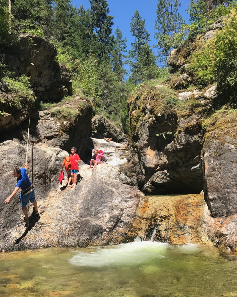
When we heard about the Ashton Creek (Enderby) natural waterslides 10 minutes east of Enderby, BC, we went for a fun, totally off-the-beaten-path adventure. It was a few years back that we were first acquainted with these mysterious, magical natural waterslides and it took us until this summer to find the gumption to finally go!
Getting To Ashton Creek (Enderby) Natural Waterslides
Head out of Enderby east along the Enderby Mabel Lake Road until you hit Ashton Creek. Just past the Tempo gas station, you'll veer left onto Rands Road, passing in front of Ashton Creek Christian Fellowship church. Follow Rands Road until you see the intersection with Olich Road and hang a right. The day we went, there were at least half a dozen cars parked along the street, so you know you're in the right place.
It's a dead end road, and the trail begins where the road stops. Follow the path for five minutes or so, and voila! You'll be at the natural waterslides.
Heading with Kids? What You Need to Know
It's more of an older kid experience. Our 7-year-old couldn't get enough while our 5-year-old was done after one run down the small slide. Our 3-year-old stuck to dry land and poked rocks with sticks the whole time.
The trail to the natural waterslides can easily be walked in flip flops or sandals. It's a straightforward and mostly flat walk. To make it a more comfortable experience when actually exploring the falls, bring along your Keens or sports sandals, or your water shoes. We didn't bring ours and wished we had.
Water coming down the slides is really cold!
We brought our kids' lifejackets and were glad we did.
Our kids stuck to the bottom slide only. The potential for knocking heads and possible concussions increases the higher up the falls you go.
On a hot day, expect to share the experience with dozens of other people, including many a folk keen on having a wee party at the slides.
Our oldest daughter, aged 7, steps down onto the natural waterslide. She couldn't get enough of it.
Hiking on Private Property?
To be honest, we're still not sure. There is almost no information to be found on the web, and we were given directions by a friend who visited a couple of years back.
This is what we DO know:
There are 'No Trespassing' and "Private Property" signs on the fence where the trail starts, but the trail swings around the side and follows the fence, without going onto that particular property.
While the trail snakes its way along through forest and is never barricaded or blocked itself, there are No Trespassing and Private Property signs on trees on both the left and right of the trail.
We don't know if the natural waterslides are on private or public land. It's just not clear. The trail could meander between two property lines, but we aren't sure.
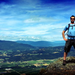
The Enderby Cliffs tower above the northern Okanagan Valley. Stunning views at the top extend as far as Vernon in the south and Salmon Arm to the north.
[caption id="attachment_2948" align="alignnone" width="834"] View from Enderby Cliffs[/caption]
The hike starts down in the valley and winds up through forest. It's a bit of a grind, ascending around 600 meters before reaching the top of the cliffs. From there it is absolutely hiking paradise, tramping around the rim of steep cliffs all the way to the highpoint, 1.5 km later.
[caption id="attachment_2940" align="alignnone" width="834"] Hiking along the rim toward Enderby Cliffs[/caption]
Directions To Trailhead:
Head north from Vernon on HWY 97A and turn right onto Cliff Rd in the centre of Enderby town. This turns into the Mabel Lake road soon after and there are useful signs along here directing to turn left 2km later onto Brash Allen Rd. At the end of this road, there is a parking lot dedicated to the hike and associated provincial park.
[caption id="attachment_554" align="alignnone" width="500"] Click on map for a higher-res version[/caption]
Distance from Vernon to Trailhead: 41km Walking time: 4-6 hours Trail Length: 14km round trip Elevation gain: 707m GPS: Not necessary Easy to Keep on Trail: yes
[caption id="attachment_2952" align="alignnone" width="3069"] View West from Enderby Cliffs[/caption]


 View from Enderby Cliffs[/caption]
 Hiking along the rim toward Enderby Cliffs[/caption]
 View West from Enderby Cliffs[/caption]
 Enderby Cliff Summit[/caption]