Commando Bay is one of many Okanagan Lake-side camp spots accessible by paddling (or long hike).

steveamie.com
steveamie.com
Commando Bay is one of many Okanagan Lake-side camp spots accessible by paddling (or long hike).

Tahaetkun Mountain is an impressive 2042m summit located north of Terrace Mountain, behind Fintry canyon in the BC Okanagan. It is seldom visited but makes for a pleasant hike for the adventurer who has already done all the rest.

Access
**note that as of Jun 2023, the easiest access via Whitemans Creek FSR (access near Sugarloaf Mt off Westside rd) is CLOSED due to a major washout**
From the north, take Douglas Lake Rd near Westwold. From the south, take the same approach as Terrace Mountain and continue on until joining with Whitemans Creek FSR.
Better yet, just check this map:

It is possible to drive quite far up the road with most vehicles and park within a couple kilometres of the summit. From there it is a bit of a bushwhack until you reach the burn line. There is a bit of scrambling but overall it is relatively short and straightforward to reach the ridgeline.
(adsbygoogle = window.adsbygoogle || []).push({});


Pennask Mountain is an insignificant peak but it does have a decent view from the summit. I opted to visit this peak via ski touring in the middle of the winter to make the journey more interesting.
(adsbygoogle = window.adsbygoogle || []).push({});

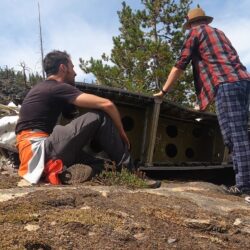
On Dec. 22, 1950 a flight from Vancouver to Penticton crashed on Okanagan Mountain. The pilot and co-pilot were killed because of the crash and the remaining 15 passengers and stewardess survived several chilly days in the wilderness awaiting rescue. There are many more details to the story and it is worth diving in further. For example, here.

A hike into the crash site is quite the adventure. It requires a substantial amount of bushwhacking and this endeavor continues to get more difficult every year as the underbrush and trees fill in (a fire in 2003 made the journey easier for a time).
Much of the wreckage was removed after the crash for salvage purposes but several large pieces still remain. The main site contains a wing and engine and has been explored by quite a few but rumour has it that the tail section remains undiscovered not terribly far from the main area.

Black Mountain Regional Park is one of the newest parklands in the Okanagan with new trails being developed all the time. As of 2023 there are 7 main trails. There are great views of Kelowna and Okanagan Lake on this rise east of the city. For entertainment value, the trail network is mediocre. There are not many trees so often it feels like walking through farmers fields. The newer trails up into the hills follow old ATV trails which are decent but far from being equal to other hiking in the Okangan.

Here are some notes about the various trails. There are now three entrances (north at Tower Ranch, main off Swainson Rd, and south in Joe Rich).
Ephemeral Pond Trail
A short loop in bare grasslands. If a pond exists, no one has found it.

sntsk‘il’ntən Trail
A newer trail just opened in 2023. The trail leads higher up the hillside than ever before, offering even better views over the city. The trail itself is built along old ATV trails and it a bit boring. It's difficult not to break into a jog to get some parts over with. There is one section that climbs up through a gully and continuing off-trail to one of the nearby lookouts or Black Knight summit is greatly encouraged. Whether starting from the main entrance or Joe Rich, the Flume Trail provides a nice loop option.

Coyote Trail
This is the main trail in from Tower Ranch. It follows the north side of a fenced off orchard. Views of new subdivisions outweigh any nature.

Hoodoo Trail
An offshoot of the Coyote Trail. This is one of the best spots in the trail network with some interesting hoodoo formations as the name suggests.

Flume Trail
Another one of the park's best trails. There is nothing left of any flume if there ever was but the trail loops through gullies and meanders through all sorts of interesting terrain. The only downside is getting to either end of this trail as it is bookended by mediocre access trails.
Grasslands Trail
One of the newer trails stretching higher up the hillside. The route follows mostly old ATV trails.

Ridge Trail
A short loop option off the Grasslands trail with decent views down over the city.

(adsbygoogle = window.adsbygoogle || []).push({});
As new trails are developed higher and higher up the hillside, one may inquire about the 'top' which is Black Knight Mountain. This is a fair question and it is 100% possible to continue on to the summit - the plan is to eventually have a manicured trail to the summit which would greatly add to the résumé of the trail network.


East Peak is really just a bump beside a bunch of other bumps. It is only really special from an alpine touring / backcountry skiing perspective. It is possible to hike across the ridge in summer from Big White summit but little reason to do so. There are few places in the Okanagan for good ski touring. Most peaks aren't tall enough to sustain good winter conditions and those that are don't have great access options. East Peak (officially Big White slack-country) has therefore become an objective both for its ease of access and height (2251m).

Access
East Peak is currently out of resort bounds, although there are future plans to one day include it in a Big White expansion. It is possible to hike over from the top of Cliff Chair but there is also a method to completely avoid the resort (and lift tickets). Park at the Black Forest parking lot and head into the backcountry by way of the snowshoeing trails. It is then possible to skin up through the forest and eventually arrive at the (south) base of East Peak.

Ski Options
The south face of East Peak (locally known as Smoker's Bowl) is the obvious route to the summit and also makes for a fantastic route down. There are a number of satisfying lines off the backside (north being the more mellow and east much steeper).

(adsbygoogle = window.adsbygoogle || []).push({});
Caution
East Peak has avalanche terrain and users must have the proper training and planning before attempting winter access. The area is also next to the popular Greystokes snowmobile lands and there could be those type of visitors accessing from the east.

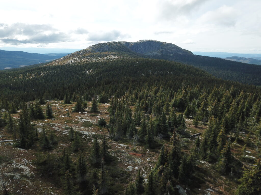
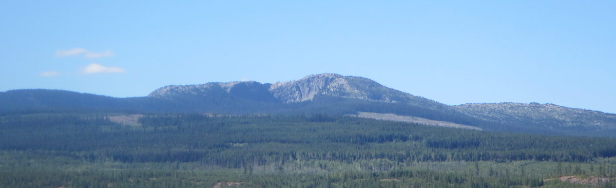
Little White - the remote and undeveloped younger sibling of that other mountain. This is one of the taller mountains in the Okanagan cracking the 2000m mark. The summit area is a huge exposed slab of rock which makes for incredible 360 views. Access to any of the trailheads requires some degree of off-roading so this is not your casual family day-hike. This also implies that some planning is required and also choosing the appropriate season (July-October).

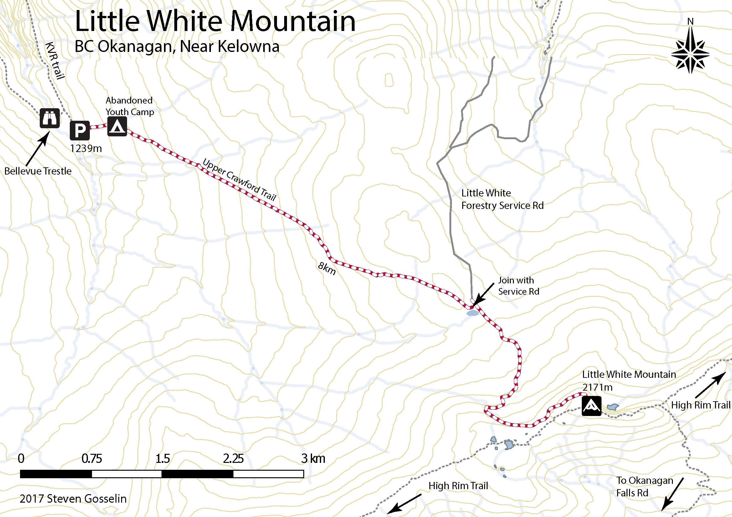
There are at least 5 different access routes for Little White - Hwy 33 / Okanagan Falls Rd / Greyback Rd / Canyon Lakes Rd, Little White forestry service road, Upper Crawford Trail, Highland trail from Chute Lake, and Highland trail from Hydraulic lake or Hwy 33.
The shortest hike up Little White is via Canyon Lakes trailhead. Unfortunately, the drive to the trailhead is much longer than others. The last 5km is doable (barely) in an SUV but a high clearance 4x4 is recommended. Take HWY 33 out of Kelowna and turn right about 20 mins later on Okanagan Falls FSR (towards hydraulic lake). Follow the signs to Idabel lake but continue past the final turnoff (to Idabel lake). 22.1 km from HWY 33 turn right at the T intersection then stay right at the Y 2.6km later. The trailhead is obvious 6.5km later (the last 5 being the really rough rocky snowmobile trail).
The most straight forward (but harder) trailhead from Kelowna is the Upper Crawford. From McCulloch Rd in south Kelowna turn onto the unpaved June Springs Forestry Service Rd and follow it all the way until it meets with the KVR (kettle valley railway) trail.
It gets a bit sketchy here but it is 100% possible with a regular car. Turn right onto the KVR - watch for cyclists ;) Drive approximately 7km along the trail until you reach the Bellevue Trestle (as far as is possible to drive). Along this route you have to navigate through some tight spaces with rock walls on either side and some precarious narrow sections with no barriers on the cliff edge. As you approach Bellevue Trestle on the right, go straight and curve left up to where there is parking and the trailhead for the Upper Crawford Trail.

The trail climbs steeply at first and after about 1km there is an abandoned Youth Corps camp. From here the trail is more gradual (mountain bikers use it) and at 5.5 km from the trailhead the path joins with the Little White Forestry Service Rd. Follow this or as the summit is clearly visible from here, make a beeline through the sparse vegetation.
(adsbygoogle = window.adsbygoogle || []).push({});

Distance from Kelowna to Canyon Lakes Trailhead
Walking time: 4-5 hours round trip
Trail Length: 12km round trip
Elevation gain: 450m
GPS: Not necessary but always a good idea for these remote hikes.
Easy to Keep on Trail: Yes, trail is well worn.
Distance from Kelowna to Upper Crawford Trailhead: 45 minutes
Walking time: 6-8 hours round trip
Trail Length: 16km round trip
Elevation gain: 930m
GPS: Not necessary but always a good idea for these remote hikes.
Easy to Keep on Trail: Yes, trail is well worn.
Technically this mountain does fall into our series hiking mountains with loud eyesore communications towers on top but we do it anyway but it is rather tactful so as to not take away from the hiking experience.
You'll notice on the map above there is an icon for Abandoned Youth Camp. The camp was abandoned in the 1990s and is worth further inspection. It can be found near the start of the Upper Crawford Trail up to Little White Mountain just off the KVR trail. One weekend we actually camped in the abandoned camp and tried to find all the items on the old map which stands at the entrance.
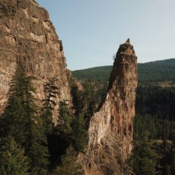

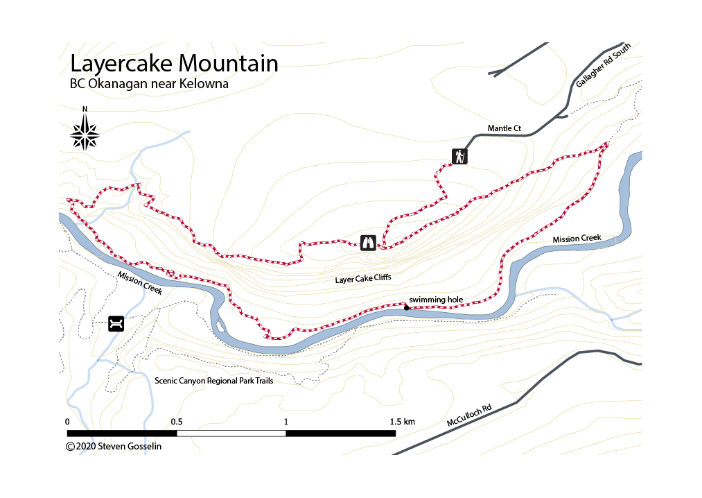
When entering Kelowna from the east (Hwy 33) this interesting geological feature is part of the breathtaking vista. It's time to get more intimately acquainted.
(adsbygoogle = window.adsbygoogle || []).push({});
Take Gallagher Road off of Hwy 33 and follow it south as it turns into Gallagher Road South and then Mantle Ct. There is an unremarkable, unsigned trail that start here.
***note that it is easy to wander onto Westbank First Nation Lands in this area. Proceed at your own risk or look into getting permission***


(adsbygoogle = window.adsbygoogle || []).push({});
From the Mantle Ct parking area it is only a few minutes up to the summit/overlook.
**proceed loudly and with caution in fall as there are bears everywhere here due to the proximity of vineyards in the area**
You would think this is the end but there is a small trail heading west along the cliffs that winds all the way down to the river below (mission creek). This trail is only seldom used and can be hard to follow. It is possible without a GPS to just follow the natural slope of the topography along the cliff.

After reaching the bottom, turn back along the base of the cliff near the river and make your way below 'the pinnacle'. It is possible here to ford the river and connect with the Greenway trail and Scenic Canyon Regional Park. The trail here along the loose shale is pretty difficult to follow. Eventually, perseverance is rewarded with a wonderful little swimming hole.
From the swimming hole, continue along the river and follow the ATV trail that wraps around the cliffs back to the top. Part of the land here is likely part of the Westbank First Nation but respectful hikers are generally permitted.

Downtown Kelowna to Trailhead: 20 mins
Trail Return time: 2-3 hours
Trail Length: 7 km loop
Elevation gain: approximately 250m down then 250m up
GPS: Not absolutely necessary
Easy to Stay on trail: Not really. Prepare to get lost (but not for too long).
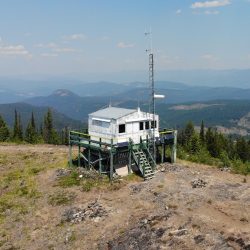
Whittaker's Hut AKA Priest Creek Cabin perches on a lookout above Kelowna in an area surrounded by Myra-Bellevue Provincial Park. The area is primarily used by off-road/ATV/snowmobile users but at certain times of year it can also be pleasant for hikers. The winter, for example, makes for a quiet and pleasant snowshoe / ski.

(adsbygoogle = window.adsbygoogle || []).push({});


Thanks to the Gallagher's Hiking Group for this one. More info here
(adsbygoogle = window.adsbygoogle || []).push({});
In the summer (2021) of never-ending forest fires, it seemed fitting to try and find the abandoned firewatch tower on Goat Peak near Beaverdell, BC for a little history lesson.
For drivers with excellent FSR driving skills, it may be possible to drive to the base of Goat Mt. For everyone else, drive as far as comfortable and then hike the rest of the way. This could mean around 5km walking along the forestry service road.
(adsbygoogle = window.adsbygoogle || []).push({});
With a 4x4 it is possible to drive up Boyer FSR out of Beaverdell to the base of Goat Lookout. We chickened out 5km short of this point due to some sketchy dugouts on the now deactivated forestry road.