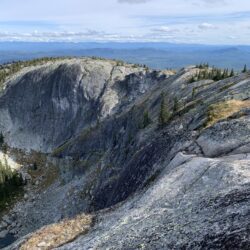
Little White - the remote and undeveloped younger sibling of that other mountain. This is one of the taller mountains in the Okanagan cracking the 2000m mark. The summit area…
steveamie.com
steveamie.com
Little White - the remote and undeveloped younger sibling of that other mountain. This is one of the taller mountains in the Okanagan cracking the 2000m mark. The summit area…
McKinley Mountain's Summit Trail, is one of the newest trails near Kelowna. There isn't a whole lot to it - a short 30-40 minute hike up a series of switchbacks…
Angel Springs trail is a pleasant walk on the slopes below the KVR trail in Myra Canyon. Normally it wouldn't be helpful in noting there are a handful of interpretive…

All I can discern about Bluehawk mine is that it was open for a year in 1934, some gold and silver was found and then it was abandoned. The opening…

Scenic Canyon Regional Park is a great one for the whole family, featuring a variety of trails and an opportunity to gawk at both of Kelowna's most spectacular geological wonders…

With its ease of access and variety of trails, Rose Valley is a premier choice for hiking in West Kelowna. There are three main areas to the regional park -…

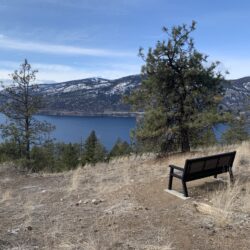
Kuiper's Peak Mountain Park is a rocky area just south of Kelowna with great views of the valley and Okanagan lake. The area is virtually treeless thanks to the 2003…

You've probably driven by Spion Kop numerous times without noticing it. Even when you look at the peak from the highway it doesn't look like anything special. That's why it's…

Many countries have their Sugarloaf hike and Canada is no exception. The Okanagan's Sugarloaf is one of those hikes that a local has to mention otherwise you might not ever…

Mill Creek Regional Park, not far from the Kelowna airport is only around 500 square meters, but packs in a lot of but packs in quite a few gems -…